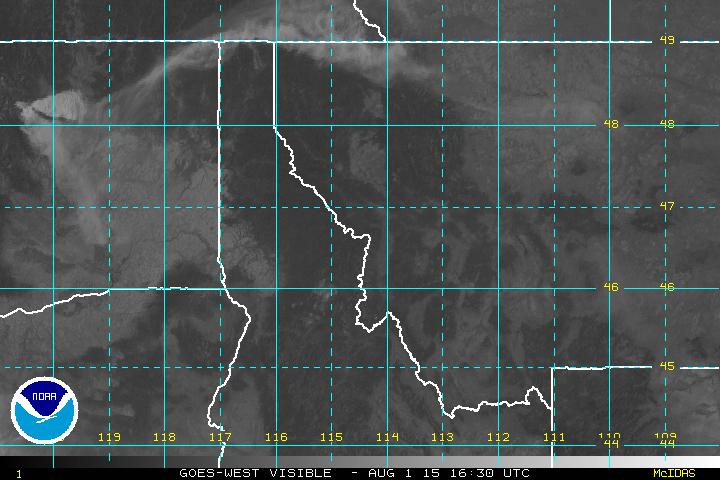
In case you’re wondering, that pall of smoke drifting through our area at a fairly high altitude is from fires in Central Washington State.
Here’s the overhead imagery showing the smoke plume:

In case you were wondering why the air looked a little murky . . .
The Flathead Valley was socked in with smoke Thursday for the first time this summer, and according to the National Weather Service most of it was drifting in from wildfires in Idaho.
“Throughout Idaho there’s a lot of smoke,” meteorologist Marty Whitmore said Thursday morning. “We were in a westerly [wind] flow earlier this week, but now we are in much more of a southwesterly flow.”
There are five fires in Idaho that have exceed 10,000 acres, including the 108,094-acre Beaver Creek Fire and the 131,258-acre Elk Complex.
From today’s Missoulian (we *ahem* covered this four days ago) . . .
The smoke we’re seeing in western Montana is coming from wildfires in British Columbia
Bridget DeRosa of the National Weather Service in Missoula said that while it was hazy in the Missoula and Bitterroot valleys, visibility was still more than 10 miles on Saturday. But it was reduced to 6 miles in the Flathead Valley around Kalispell.
Starting yesterday, several folks in the North Fork reported smelling smoke. That smoke may be coming from Canada. NOAA’s early morning “Hazard Mapping System Fire and Smoke Product” map (see below) showed an extensive smoke plume drifting to the south and east from a large wildfire complex in southern British Columbia. At latest report, BC has some 318 wildfires, the bulk of them in the southern half of the province.
For more information on wildfires in Canada, keep an eye on the Canadian Wildland Fire Information System page.