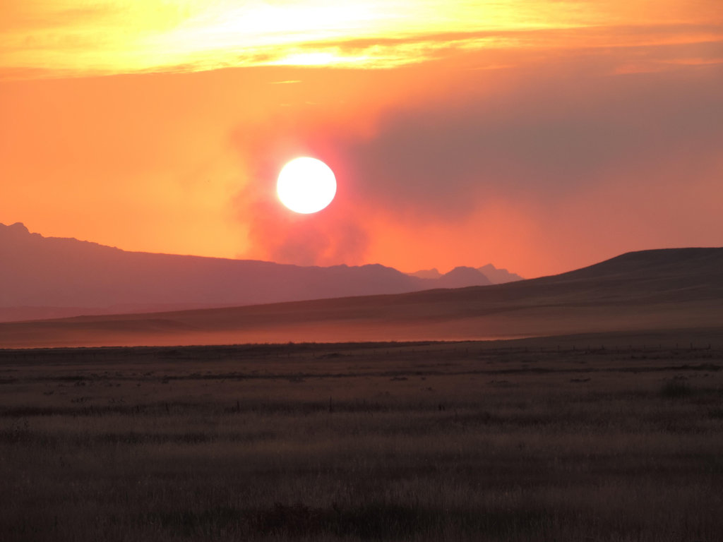
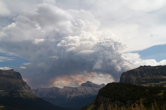
A column of smoke from the Glacier National Park Thompson Fire could be seen rising over the Rocky Mountain Front at sunset Aug. 12, 2015. The remote backcountry fire has burned about 14,900 acres. (Photo by Jonathan Moor)
Short version: Cooler weather and last night’s rain should cause the fire to lay down a bit. They still intend to fly in a couple of ground crews . . .
If weather and smoke conditions permit today, two crews will fly into the backcountry area near the fire to work on control measures. One crew will land near Cutbank Pass to suppress hot spots along the fire’s edge and direct helicopter water drops. The other crew will work in the Nyack Drainage area to provide additional structure protection measures for the Upper Nyack Backcountry Patrol Cabin; cool down hot spots along the fire perimeter; direct helicopter water drops; and use pumps and hoses on any hot spots along the perimeter.
Gusty winds are predicted for the area through the morning with a chance for showers. Cooler weather and higher humidity are expected today, with a return to seasonal conditions Sunday. With cooler weather and recent rains, the fire is expected to smolder within its perimeter today. West Glacier received about 0.06 inches of rain in the past 24 hours: St. Mary received 0.19 inches…
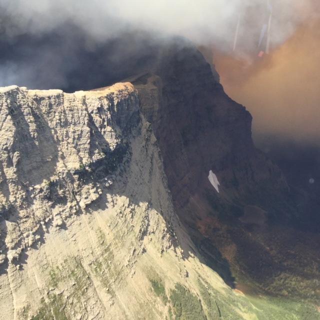
Thompson Fire burning on west side of Cut Bank Pass, Aug 12, 2015
From this evening’s incident update on the Thompson Fire we learn that the fire’s size estimate has been trimmed slightly to 13,202 acres and that they hope to start flying fire crews into the backcountry to fight the blaze on the ground . . .
A small fire was detected today on the west side of Waterton Lake on the U.S. side in Glacier National Park. Fire personnel are responding.
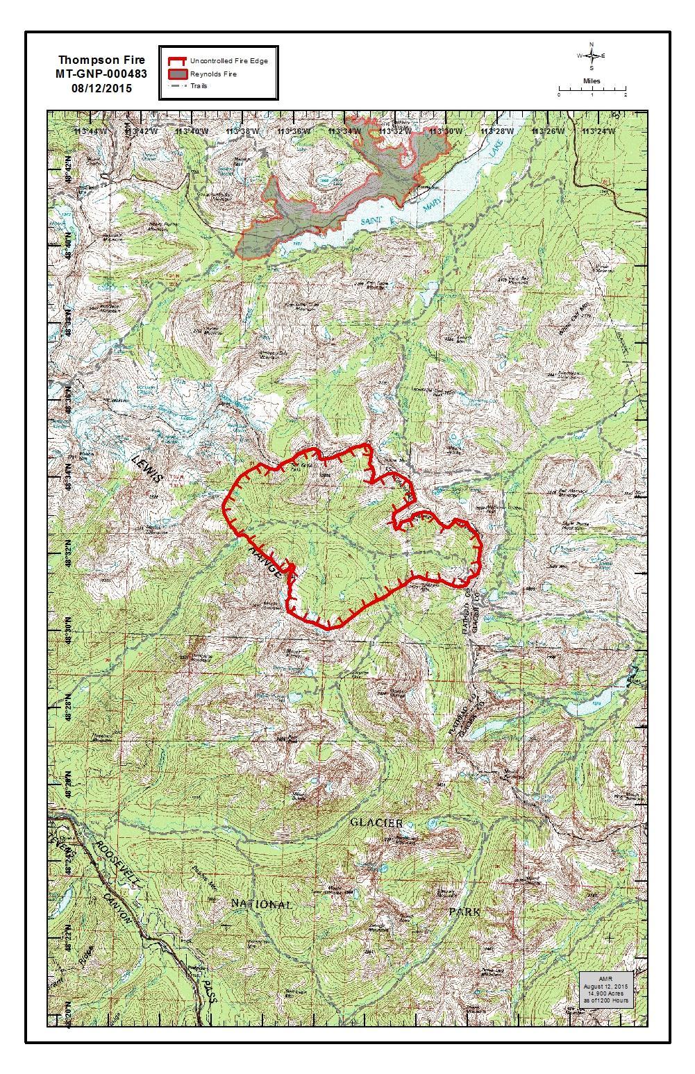
The Thompson Fire was reported at approximately 1:30 p.m. Sunday, Aug. 9. It is located in a remote south-central backcountry area of Glacier National Park about 15 miles east of the West Glacier entrance and 12 miles southwest of the Saint Mary entrance. The fire is burning in the Thompson Creek and Nyack Creek drainages west of Medicine Grizzly Peak where the Flathead and Glacier Counties border follows the Continental Divide.
If weather and smoke conditions permit, two crews will fly into the backcountry area near the fire to work on control measures. One crew will land near Cutbank Pass to suppress hot spots along the fire’s edge and direct helicopter water drops. The other crew will work in the Nyack Drainage area to provide additional structure protection measures for the Upper Nyack Backcountry Patrol Cabin; cool down hot spots along the fire perimeter; direct helicopter water drops; and use pumps and hoses on any hot spots along the perimeter.
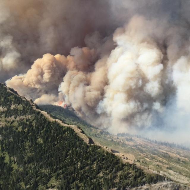
Thompson Fire burning on west side of Continental Divide, Aug 12, 2015
Here’s a good summary of the fire situation in this corner of Montana right now . . .
Eight major fires are burning across the region Friday and officials say the situation could worsen this afternoon as a weather system brings gusty winds and thunderstorms amid historically dry conditions.
The National Weather Service in Missoula issued a red flag warning starting at noon for the entire northern half of Montana.
“If something new starts in the right spot it could be catastrophic,” said Lincoln Chute, Flathead County fire service area manager.
A column of smoke from the Glacier National Park Thompson Fire could be seen rising over the Rocky Mountain Front at sunset Aug. 12, 2015. The remote backcountry fire has burned about 14,900 acres. (Photo by Jonathan Moor)
This morning’s press release on the Thompson Fire . . .
Northern Rockies Type II Incident Management Team
Irv Leach Incident Commander
Daily Fact Sheet Aug. 14, 8:00 a.m.
Link to http://inciweb.nwcg.gov/incident/4468/Fire Information: (406) 314-1669 8 a.m.-8 p.m.
Approximate Size: 14,900 acres Containment: 0% Latitude 48.551, Longitude -113.613
Fire Update: The Thompson Fire was reported at approximately 1:30pm on Sunday, August 9. It is located in a remote south-central backcountry area of Glacier National Park about 15 miles east of the West Glacier entrance and 12 miles southwest of the Saint Mary entrance. The fire is burning in the Thompson Creek and Nyack Creek drainages west of Medicine Grizzly Peak where the Flathead and Glacier Counties border follows the Continental Divide.
The safety of public and incident personnel is the highest priority on all incidents. Aerial resources are being used on the Thompson Fire to control fire spread. Helicopters dropped water on hot spots in the Nyack Creek drainage.
No structures have been lost or damaged. Structure protection is in place at the Lower Nyack Backcountry Patrol Cabin. The threat to the Upper Nyack Cabin was reduced when the fire burned around it.
A cold front is expected this afternoon with increasing winds and possible strong thunderstorms. A Red Flag Warning for fire behavior is in effect from noon to midnight. Strong winds will first come from a southerly direction,
turning westerly behind the front. Strong thunderstorms capable of gusty winds and hail are also expected. Cooler weather and higher humidity are expected Saturday, with a return to seasonal conditions Sunday.
Some of the smoke to the east is from the Thompson Fire. However, much of the smoke in the region is from fires west of Glacier in California, Washington, Oregon and Idaho. There are 188 fires burning nationally, including 66 in the Northern Rockies.
Call (406) 314-1669 for updated fire information.
Glacier National Park is under Stage I Fire Restrictions. Campfires are not allowed in the backcountry of Glacier National Park. Campfires are still allowed in developed campgrounds that have park-provided concrete or metal fire rings.
Closures: The Thompson Fire has prompted closure of the Nyack and Coal Creek areas, including trails and backcountry campsites. There may be additional trail closures in the area due to increased fire activity. For updated information on trail status, visit http://home.nps.gov/applications/glac/infobull/closures.cfm.
Trail Closures:
Siyeh Pass Trail, from Siyeh Pass to Sun Rift Gorge
Sunrift Gorge, Saint Mary Falls, and Virginia Falls
Red Eagle Trail, towards Saint Mary Falls
Otokomi Trail
Coal Creek Trail
Nyack Creek Trail
Cutbank Pass Trail, in the Nyack drainage
Park Creek to Coal Creek cutoff trail
Dry Fork Trail, from Pitamakan Pass to Two Medicine Campground trailhead and Two Medicine Entrance
Morning Star Trail, from Cutbank Auto Campground to Pitamakan Pass
Atlantic Creek Trail, from Cutbank Auto Campground to Triple Divide Pass
Medicine Grizzly Lake Trail
Dawson Pass Trail / North Shore of Two Medicine Lake
North Shore Two Medicine Junction to Dawson / Pitamakan
Upper Two Medicine Lake Trail
Campground Closures:
Cutbank Frontcountry Campground
Rising Sun Frontcountry Campground
Otokomi Backcountry Campground
Reynolds Backcountry Campground
Lower Nyack Backcountry Campground
Upper Nyack Backcountry Campground
Beaver Woman Lake Backcountry Campground
Nyack/Coal Creek Camping Zone
Coal Creek Backcountry Campground
Atlantic Creek Backcountry Campground
Morning Star Backcountry Campground
Oldman Lake Backcountry Campground
No Name Backcountry Campground
Upper Two Medicine Lake Backcountry Campground
The Reynolds Creek Fire continues to burn within the fire perimeter on the east side of the park. For information on fires within Glacier National Park, please visit http://inciweb.nwcg.gov/state/27/.
The Thompson Fire has not impacted any park roads. The Going-to-the-Sun Road is open.
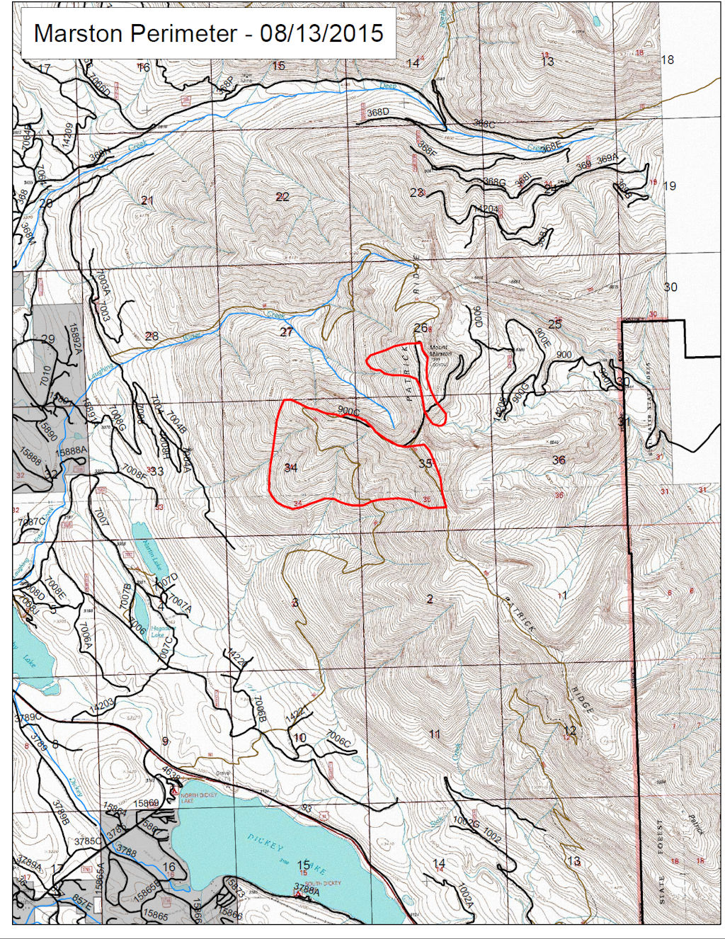
UPDATEDto include newer information, including several corrections from Jon Cohan, who can see the Marston Fire from his back deck. Here’s what he has to say: “The Mt. Marston fire started overnight on Mon. during a lightning storm and was spotted early on Tues. morning by a local USFS crew who were in action as early as 8:00 am. The fire initially started on the southwest slope facing Rte. 93 and grew as it traveled uphill during the day. It has grown considerable larger since then, overtaking the peak and spreading to nearby terrain via ember deposits.”
The smoke plume from the Marston Fire is visible from the North Fork. It is burning on Mt. Marston in the Kootenai National Forest, a little over 4 air miles east of Fortine and about 21 miles west of Polebridge.
According to the InciWeb page, fire crew access is limited due to steep terrain. The Mt. Marston Lookout is threatened by the blaze and has been bundled up in fire retardant wrap. The most recent report puts the fire’s size at 550 acres.
Thompson Fire burning on west side of Continental Divide, Aug 12, 2015
The Thompson Fire grew to 14,900 acres (over 23 square miles) today and a Type II management team takes over tomorrow. Here’s the official news release . . .
The Thompson Fire expanded east yesterday and today into the higher elevations of the upper Nyack Creek area, located in the south-central region of Glacier National Park. The cause of the fire is under investigation.
The Thompson Fire is now estimated to be 14,900 acres. Dry vegetation coupled with high temperatures and low humidity resulted in extreme fire behavior and fire growth yesterday and today. The smoke plume has been visible from many locations on both sides of the Continental Divide.
A Type III Interagency Incident Command Team has been working with Glacier National Park to manage the fire using a contain and confine strategy. A Type II Incident Management Team has been ordered and will assume command of the fire tomorrow morning.
The safety of public and incident personnel is the highest priority on all incidents. At this time, ground resources cannot be safely used due to the remote, rugged terrain and the lack of safety zones in the area. The National Park Service’s Upper and Lower Nyack Backcountry Patrol Cabins remain threatened by the fire.
Yesterday’s fire activity has prompted expansion of the trail and campground closure order. For the most up-to-date information on the expanded trail and area closure statuses, visit http://home.nps.gov/applications/glac/infobull/closures.cfm.
As of Wednesday, August 12, campfires will not be allowed in the backcountry of Glacier National Park. Campfires will continue to be allowed only in designated sites in frontcountry campgrounds. Stage 1 fire restrictions remain in effect for Northwest Montana. For further information visit: http://www.nps.gov/glac/learn/news/fire-restrictions-for-back-country-of-park.htm.
The Reynolds Creek Fire continues to burn within the fire perimeter on the east side of the park. For information on fires within Glacier National Park, please visit http://inciweb.nwcg.gov/state/27/.
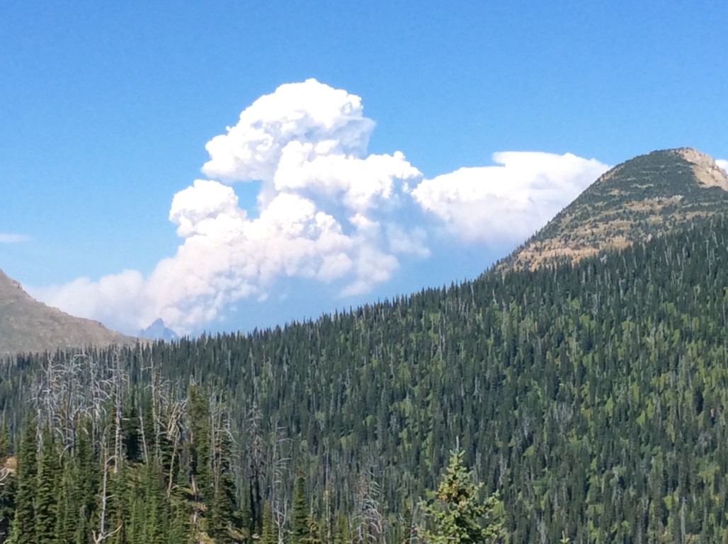
Smoke Plume from the Thompson Fire as seen from Logan Pass – NPS PHOTO-Andrew Englehorn
From an August 11, 2015 Glacier National Park press release . . .
As of Wednesday, August 12, campfires will not be allowed in the back country of Glacier National Park. Campfires will continue to be allowed only in designated sites in front country campgrounds.
Glacier National Park Superintendent Jeff Mow said, “The park is experiencing extreme fire conditions and to help reduce the risk of fire, we are implementing fire restrictions for our back country campgrounds and recreation sites.” Mow continued, “The back country restrictions will help to protect public and employee safety, as well as protect park resources and facilities.”
Only liquid petroleum or LPG-fueled stoves, lanterns or heating devices will be allowed in back country campgrounds in Glacier National Park.
At this time, campfires are only allowed in park-provided metal or concrete fire rings located in front country campgrounds in Glacier National Park. These campgrounds include:
Apgar
Avalanche
Bowman Lake
Cut Bank
Fish Creek
Kintla Lake
Logging Creek
Many Glacier
Quartz Lake
Sprague Creek
St. Mary
Two Medicine
PLEASE NOTE: Stage 1 fire restrictions remain in effect for Northwest Montana. Stage I fire restrictions apply to campfires and smoking. During Stage I, “Building, maintaining, attending, or using a fire or campfire” is prohibited unless noted in the exemptions. Exemptions include fires fueled solely by liquid petroleum or LPG, or other activities for which there is a permit or written authorization. In addition to the campfire restrictions, smoking is prohibited unless within an enclosed vehicle, building, or in an area three feet in diameter, that is barren or cleared of all flammable materials. Stage 1 restrictions apply to:
* Flathead National Forest
* Kootenai National Forest
* Bob Marshall Wilderness Lands within the Flathead National Forest
* Glacier National Park
* Confederated Salish and Kootenai Tribes
* U.S. Fish & Wildlife Service
* MT-DNRC Northwestern Land Office
* Montana Fish Wildlife and Parks Region 1
* Counties: Flathead, Lake, Lincoln, and Sanders
* Property within city limits in the area are EXEMPT from this order
The restrictions will remain in effect until there is a significant long-term change in fire danger.
The Thompson Fire in Glacier Park notwithstanding, Tuesday was a fiery day throughout Northwest Montana.
An early morning fire led Flathead National Forest officials to temporarily close Jewel Basin Road, which reopened Tuesday afternoon after crews put out the small, lightning-caused fire near Noisy Creek.
Spotted early in the morning north of the lower segment of the gravel road, the fire was stopped at a quarter of an acre after firefighters from the forest and the Montana Department of Natural Resources and Conservation crews hit it with a light helicopter and finished containment lines by Tuesday afternoon. There were no trail closures associated with the fire.
Thompson Fire from Baptiste LO, Aug 11, 2015, 405pm – courtesy Debo Powers
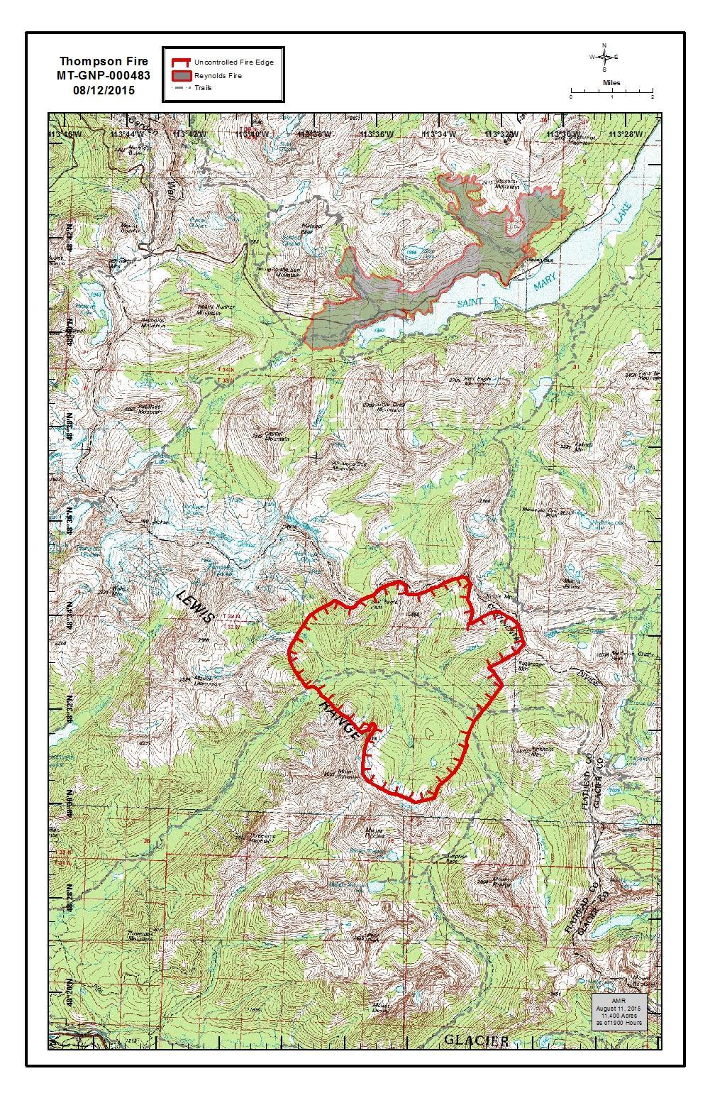
Woof! The Thompson Fire is now estimated at 11,400 acres, almost 18 square miles. A type II team has been called in.
The Missoulian has a good write-up. Also check out the map below to see the area covered by the blaze . . .
The Thompson fire in southeastern Glacier National Park exploded from 1,900 acres to about 11,400 acres between Monday and Tuesday afternoons, as western Montana recovered from a line of thunderstorms Monday night.
“The lack of moisture, high temperatures, low humidity and dry vegetation have resulted in extreme fire behavior and fire growth,” Glacier spokeswoman Katelyn Liming said in an email Tuesday. “The smoke plume is visible from areas on both the west and east sides of the Continental Divide.”
Given the fire’s remote location, the National Park Service is using a “contain and confine” strategy to manage it, Liming said. Helicopters are using bucket drops to cool its hot spots, while natural rock outcrops are blocking some of the spread.
Thompson Fire from Baptiste LO, Aug 11, 2015, 405pm – courtesy Debo Powers
The Thompson Fire is now five times as big as it was at the end of the day yesterday. Here is this afternoon’s official press release . . .
The Thompson Fire started on August 9th and continues burning in the remote Nyack area, located in the south-central region of the Glacier National Park. The cause of the fire is under investigation.
The lack of moisture, high temperatures, low humidity, and dry vegetation have resulted in extreme fire behavior and fire growth. The Thompson Fire is now estimated to be 5,500 acres this afternoon. The smoke plume is visible from areas on both the west and east sides of the Continental Divide.
A Type III Interagency Incident Command Team is working with Glacier National Park to respond to the fire. There are currently 35 fire personnel and two helicopters assigned, with additional air resources available. A Type II Incident Management Team has been ordered. The Team is using contain and confine strategy to manage the fire. This is being accomplished by using aerial resources with water bucket drops to cool hotspots. Fire managers are using natural (rocky) barriers to confine the fire. The National Park Service Upper and Lower Nyack Backcountry Patrol Cabins remain threatened by the fire. Containment actions are being taken to protect the lower cabin. These actions include fuel mitigation actions around the site and structure wrap of the cabin.
The safety of public and incident personnel is the highest priority on all incidents. At this time, ground resources cannot be safely used due to the remote, rugged terrain and the lack of safety zones in the area.
The Thompson Fire has prompted closure of the Nyack and Coal Creek areas, including trails and backcountry campsites. There will be additional trail closures in the area due to increased fire activity. For updated information on trail status, visit http://www.nps.gov/glac/planyourvisit/trailstatusreports.htm.
The Reynolds Creek Fire continues to burn within the fire perimeter on the east side of the park. For information on fires within Glacier National Park, please visit http://inciweb.nwcg.gov/state/27/.