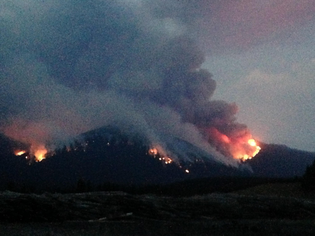
U.S. Highway 2 is going to be closed while crews deal with the approaching Sheep Fire . . .
Authorities closed a section of U.S. Highway 2 near Essex on Thursday to provide safe access for firefighters battling the Sheep Fire, a 232-acre blaze that has grown to within 1 mile of the highway and river corridor near the southern boundary of Glacier National Park.
There are no evacuation orders, but Flathead County Sheriff Chuck Curry and his deputies notified 106 residents in and around Essex that they must prepare to leave and recommended they begin loading their cars immediately, Flathead County emergency information officer Jennifer Rankosky told the Associated Press. Forty-two people were home and notices were left at the rest of the homes…
The highway closure was announced Thursday afternoon for the seven-mile section of highway from milepost 178 to 185, from the Halfway Motel near Pinnacle on the west side to Bear Creek on the east side. A section of railway is also being closed. The highway and railway will reopen once conditions are safe, authorities say.
Here are the highlights of the Thompson Fire evening update. No surprises, but some progress on the ground . . .
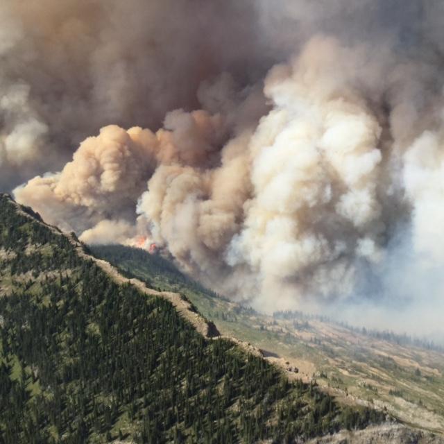
Fire Update: The Thompson Fire was reported at approximately 1:30 p.m. Sunday, Aug. 9. It is located in a remote south-central backcountry area of Glacier National Park about 15 miles east of the West Glacier entrance and 12 miles southwest of the Saint Mary entrance. The fire is burning in the Thompson Creek and Nyack Creek drainages west of Medicine Grizzly Peak where the Flathead and Glacier Counties border follows the Continental Divide. No structures have been lost or damaged to date and no injuries have been reported.
Crews worked in the Nyack Creek area today. A helitack crew worked on cooling any remaining hot spots around Upper Nyack Backcountry Patrol Cabin to provide additional structure protection. Other crews began constructing a wet line along avalanche chutes on the west side of the fire’s perimeter to contain the fire. This includes the use of helicopter water drops and pumps and hose lays on the ground. Fire personnel in the Two Medicine and Cut Bank drainages continued their structure assessment for possible protection if the fire were to cross the Continental Divide. They are also monitoring for any fire that might cross the Divide.
Although buffeted by winds on Friday, the fire remains west of the Divide and has not made any advance to the east. Without spread east of the Divide, the fire poses no threat to communities around East Glacier and St. Mary. Limited growth of the fire was seen on Saturday on the west side in Nyack Creek.
Weather will remain unsettled through Monday night with the passage of a weak disturbance. This provides an opportunity for afternoon thunderstorms and a slight chance of rain, especially along the Divide. A high pressure ridge will begin building on Tuesday through Thursday bringing warmer and drier conditions. This will bring increased fire spread on the ground with isolated tree torching. As fuels in the burn area dry, there will likely be an increase in smoke production that may be seen from local communities on both sides of the Divide.
A cluster of wildland fires on the west side of the Whitefish Divide is now being handled as the “Northeast Kootenai Complex” under the control of Shawn Pearson’s Type II Incident Management Team. By far the largest fire in this group — and the one of primary interest on the North Fork — is the Marston Fire. Others include the Barnaby, Sunday, Weigel and Dunn blazes.
Information Officers: Claire Pitner, Katie Knotek, Tom Rhode & Meg Nemitz
Fire Information Line: (406) 882-8308
Office hours: 8:00 a.m. to 8:00 p.m.
Email: northeastkootenaicomplex@gmail.com
INCIDENT: Northeast Kootenai Complex; The complex includes the Barnaby, Marston, Sunday, Weigel and Dunn Fires.
AGENCY JURISDICTION: USDA Forest Service, Kootenai & Flathead National Forests; Montana DNRC, Libby and Stillwater Units.
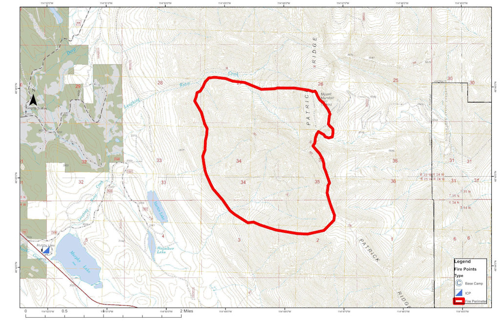
INCIDENT COMMANDER: Shawn Pearson, Northern Rockies Type II Incident Management Team (IMT). The Incident Command Post (ICP) is located at the Murphy Lake Ranger Station.
WEATHER & FIRE BEHAVIOR: Weather today will be similar to yesterday with cooler temperatures (mid-70s) and higher relative humidity (20-30%). This will continue to moderate fire behavior on all fires, with little to no fire growth expected.
MARSTON & BARNABY FIRES: The Marston Fire is estimated at 1,500 acres and the Barnaby Fire at 5 acres. Both fires are located near Eureka, MT on the Fortine Ranger District, Kootenai National Forest. Today on the Marston Fire, firefighters will continue work on a fuel break on the east side of Deep Creek. On the Barnaby Fire, a Hotshot crew will hike into the fire area to assess the situation and plan for future operations. No evacuations are currently in effect for either of these fires.
WEIGEL & DUNN FIRES: The Weigel Fire is approximately 100 acres and the Dunn Fire is 74 acres. Both fires are located near Libby, MT on the Libby Ranger District, Kootenai National Forest. Fireline has been established around the full perimeter of each fire. Today, firefighters will continue wetting along the fireline and into the fire perimeter.
SUNDAY FIRE: The Sunday Fire is approximately 150 acres and is located on the Tally Lake Ranger District, Flathead National Forest and Fortine Ranger District, Kootenai National Forest. Fireline has been constructed around a good portion of the fire perimeter. The focus today will be to snag hazard trees in the fire area before completing the remaining line construction.
PERSONNEL AND RESOURCES: 224 personnel, including 2 – Type 1 crews, 2 – Type 2 crews, 16 engines, 7 dozers, 3 feller-bunchers, 6 skidgons and 6 water tenders.
SPECIAL MESSAGES/CLOSURES: An area closure is in effect for the Marston Fire and is posted on Inciweb. A community meeting will be held tonight at the Trego Civic Center at 7:00 p.m.
The Kootenai National Forest is scrambling to deal with a number of new wildfires . . .
The Kootenai National Forest added 14 new fires Saturday to its growing list that totals 49 wildfires that have started since Aug. 1.
Lightning raked the forest Friday night, igniting new fire starts.
The largest fire — the Marston Fire near Trego — had grown to 1,500 to 1,800 acres as of Saturday afternoon, according to Kootenai National Forest Public Information Officer Willie Sykes.
The folks in the Spotted Bear District have their hands full this fire season . . .
The Spotted Bear Ranger District remains the hot spot for fires on the Flathead National Forest, with eight new fires started by Friday’s lightning storms.
Spotted Bear has 19 fires while the rest of Flathead National Forest has four…
The largest fire is the Trail Creek Fire. By Saturday, it had burned 2,500 acres north of the Spotted Bear River…
Approximate Size: 13,680 acres Containment: 0% Latitude 48.551, Longitude -113.613 Resources – Total Personnel: 111 Injuries: None Hand Crews: 1 Wildland Fire Management Module Air Support: Helicopters (1 Type-1 & 1 Type-3) 1 Helitack Crew
Fire Update: The Thompson Fire was reported at approximately 1:30 p.m. Sunday, Aug. 9. It is located in a remote south-central backcountry area of Glacier National Park about 15 miles east of the West Glacier entrance and 12 miles southwest of the Saint Mary entrance. The fire is burning in the Thompson Creek and Nyack Creek drainages west of Medicine Grizzly Peak where the Flathead and Glacier Counties border follows the Continental Divide. No structures have been lost or damaged to date and no injuries have been reported.
A crew was flown into the Nyack drainage area Saturday evening and established a spike camp to operate from. They will provide additional structure protection measures for the Upper Nyack Backcountry Patrol Cabin, including helicopter water drops if needed. They are constructing a wet line along avalanche chutes to contain fire from further spread. This includes the use of helicopter water drops and pumps and hose lays on the ground. A helitack crew is positioned at the helibase along US Highway 2 to provide support to Glacier NP fire managers in the event of any new fire starts. Fire personnel in the Two Medicine and Cut Bank drainages are assessing structures for possible protection if the fire crosses the Continental Divide. They are also monitoring for any fire slopover across the Divide.
Although buffeted by winds on Friday, the fire remains west of the Divide and has not made any advance to the east. Without spread east of the Divide, the fire poses no threat to communities around East Glacier and St. Mary. Limited growth of the fire was seen on the west side in Nyack Creek.
Sunday’s weather will remain cool with temperatures on the fire in the lower to mid-50s. Humidity will remain higher around 50%. Wind will be lighter at 12-16 mph from the southwest on ridges. Decreasing winds are predicted for the area by morning with a slight chance for showers. Temperatures will slowly increase and humidity decrease over the next several days, with a return to seasonal conditions. There is a slight chance for isolated thunderstorms and rain later in the day on Sunday.
Here’s the noon update on the Marston Fire. Short version: The blaze is up to about 1500 acres. Shawn Pearson’s Type II team will be taking over tomorrow (Sunday) morning, which means they are taking this fire pretty seriously.
FIRE UPDATE
Marston Fire
Fortine Ranger District, Kootenai National Forest
August 15, 2015, 12:00 p.m.
Fire Information Line: (406) 882-8308 starting August 15
Office Hours: 8:00 a.m. to 8:00 p.m.
What: Wildland Fire Detected: August 11, 2015 Cause: Lightning Current Size: Estimated 1,500 Acres Containment: 0% Resources on Fire: 3 feller bunchers, 2 skidders, 1 dozer, 2 dozer bosses, 1 dozer boss trainee, 15 district fire personnel Location: Approx. 15 miles SE of Eureka, MT on the Fortine District of the Kootenai National Forest.
Status: Due to steep terrain, extremely dry fuels, high temperatures and low humidities, the fire grew significantly yesterday. Firefighters worked on establishing a contingency line in the Laughing Water/Summit Creek area with feller bunchers and dozers. Local district personnel responded to several lightning strikes/new fire starts with initial attack. A trace of rain fell on the fire overnight.
Today the weather is expected to be overcast with cooler temperatures (60-70° degrees) and a higher relative humidity. These conditions should moderate fire behavior. Firefighters are working on building a fuel break on the East side Deep Creek.
Shawn Pearson’s Northern Rockies Type 2 Incident Management Team is onsite at the Fortine Ranger District and will be transitioning with the district personnel. The team is expected to take command of the fire on Sunday, August 16.
Special Messages/Closures: The top priority is firefighter and public safety. Closures in the Marston face area, Stillwater area, and Laughing Water area remain in effect. An expanded area closure went into effect early this morning and is posted on inciweb.There are no evacuations in effect at this time.
There will be a community meeting at the Trego Community Hall at 7:00 pm on Sunday evening, August 16.
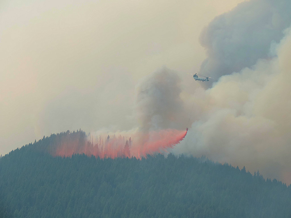
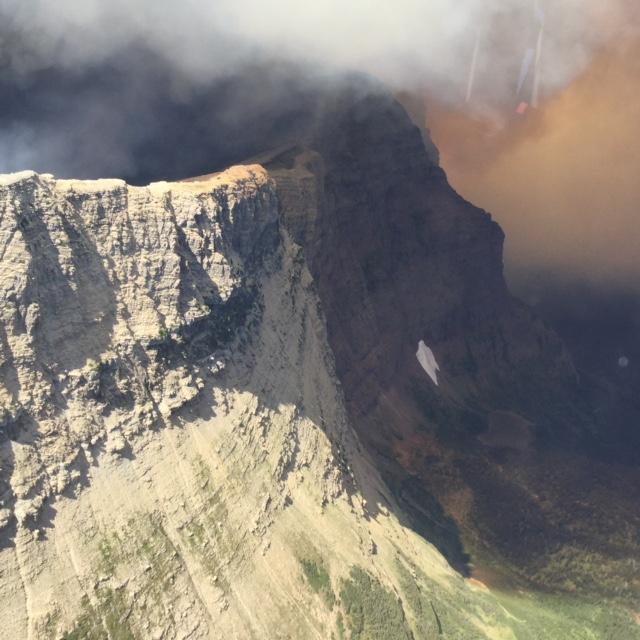
Thompson Fire burning on west side of Continental Divide, Aug 12, 2015
Lightening triggered more fires throughout this corner of the state as yesterday’s storms swept through . .
As thunderstorms swept through Northwest Montana on Friday, wind, lightning and parched conditions created dozens of new fires while fanning the flames of existing ones.
Five separate wildfires are now burning at more than 1,000 acres apiece throughout the region, including the new Trail Creek and Marston fires, burning at 1,300 and 1,200 acres, respectively.
On the Kootenai and Flathead national forests, there were 55 active fires burning Friday night.
The Marston Fire ballooned up to 1200 acres. A Type II team is due on site tomorrow (Sunday) morning . . .
As many as 26 new fires had been reported in the Kootenai National Forest area by Friday evening, with a previously reported pair of fires on Mount Marston erupting to cover 1,200 acres.
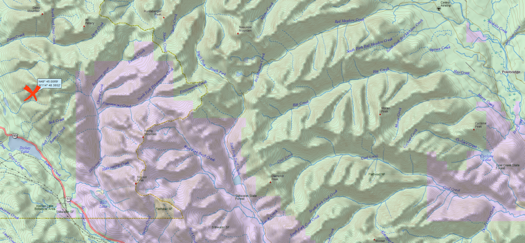
The two fires were being managed as a single incident dubbed the Marston Fire and are burning about two miles northeast of Dickey Lake and four miles northeast of Trego.
The fires are threatening the Mount Marston Lookout.