From the official press release . . .
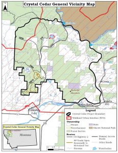
The Hungry Horse-Glacier View Ranger District of the Flathead National Forest is asking for public input on management opportunities on National Forest System lands north of Columbia Falls and west of the Flathead River. This area includes Crystal Creek, Cedar Flats, Spoon Lake, Blankenship, and Teakettle Mountain.
The Crystal Cedar project aims to reduce hazardous fuels in the wildland-urban interface, improve the health and diversity of forest vegetation communities, and provide a range of trail-based recreation opportunities near the community of Columbia Falls.
The Flathead National Forest wants to hear from you. We want to understand how the community uses the area and what types of management you want to see. Comments are most helpful if provided by December 15, 2017.
More details about the Crystal Cedar project area, a map of the project area, and instructions on how to provide information to the district can be found online at https://www.fs.usda.gov/project/?project=52844. The Web site also allows you to subscribe to electronic updates on the project so you can stay up to date on project development.
To find out more about the project, please contact Sarah Canepa, project team leader, at the Hungry Horse Ranger Station, 406-387-3800.