Here’s the morning update for the Thompson-Divide Complex fires, including the Granite, Sheep and Thompson fires.
The big news continues to be the Sheep Fire, which triggered an evacuation order for Essex a few days ago. The Essex evacuation order was lifted yesterday and U.S. Route 2 was reopened for normal traffic. The arrival of cooler, wetter weather has helped firefighters throughout the region.
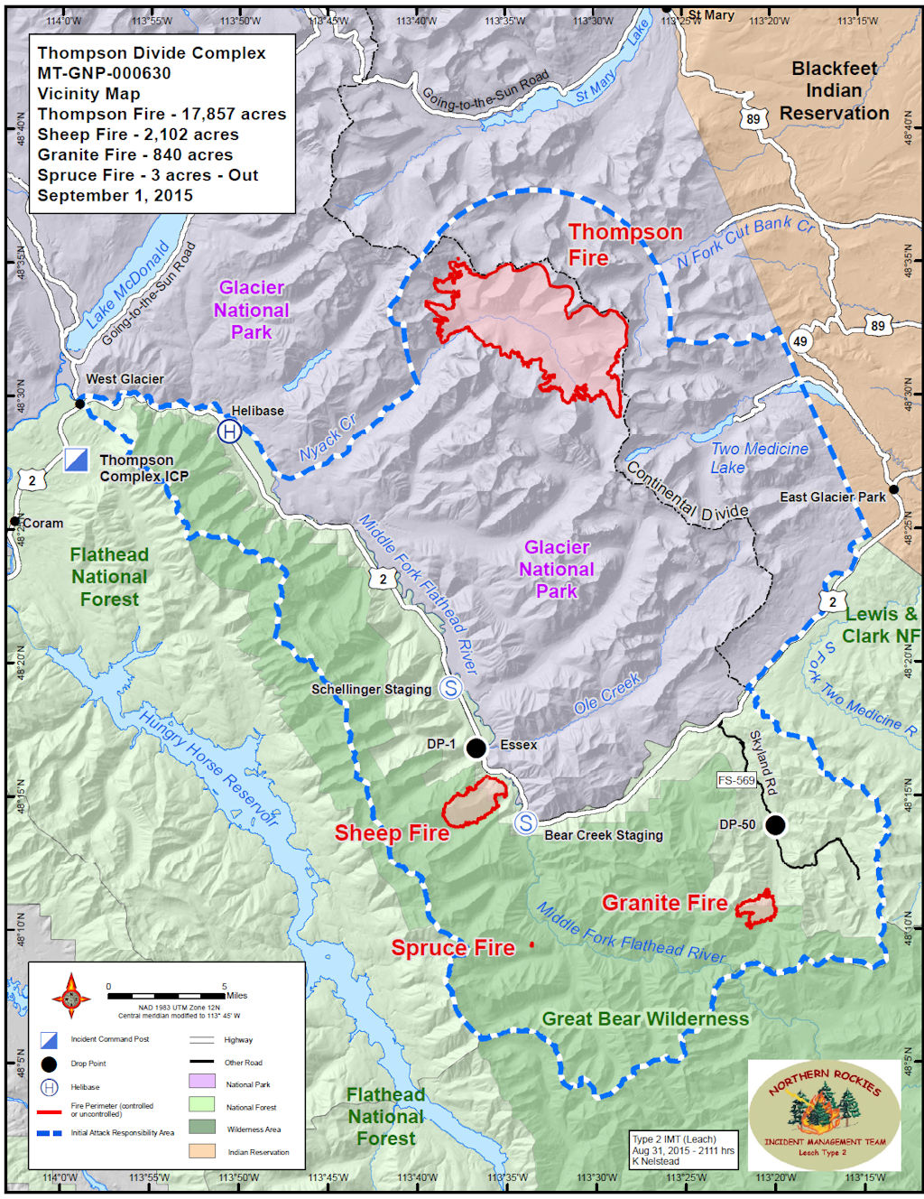
For a view of the positions and relative sizes of the fires in this group, see the “Thompson-Divide Complex Vicinity Map” at the end of this post . . .
Fire Information: (406) 387-4854/ (406) 314-1669, 8 a.m. – 8 p.m.
Fire Complex Completed: 24%
Resources – Total Personnel: 332 Injuries: 1 Structures Lost: None
20-Person Hand Crews: 2 Type-1 and 3 Type-2, 1 Wildland Fire Management Module (8), 1 Helitack Crew (10)
Air Support: Helicopters (2 Type-1 & 2 Type-3), Engines: 18 Heavy Equipment: 14
The Thompson-Divide Complex is comprised of the Sheep and Granite Fires on the Flathead National Forest and the Thompson Fire in Glacier National Park. The Sheep fire is the incident priority due to its proximity to US Hwy. 2, BNSF railway and the community of Essex.
On Aug. 31, Flathead County Sheriff Chuck Curry lifted the mandatory evacuation order for Essex and the surrounding area and placed the community back to the ‘Set’ Stage of the Ready, Set, Go evacuation model. Residents are advised to remain prepared to evacuate if conditions again warrant this action. For more information on the evacuation, call the Flathead County Office of Emergency Services at (406) 758-2111.
On Aug, 31, U.S. Highway 2 reopened with pilot cars escorting traffic between mileposts 176.5 at Schellinger Gravel Pit and 185 at Bear Creek. Escorted vehicles are not allowed to stop in this area. BNSF and Amtrak trains are running normally. Call 511 or visit http://www.mdt.mt.gov/travinfo/alerts.shtml for current road status. For more information on Amtrak call (800) 872-7245.
Stage II Fire Restrictions are in effect for northwestern Montana.
Visit http://svc.mt.gov/deq/todaysair/ for air quality info.
Closures are in effect for some trails and areas in the vicinity of the fires for Glacier National Park and Flathead National Forest. For more info, see the Glacier NP page http://www.nps.gov/glac or for Flathead NF call Hungry Horse Ranger District (406) 387-3800 or go to http://inciweb.nwcg.gov/incident/article/4468/28364/.
Low pressure weather patterns will continue to effect the fire complex area thru the weekend. Temperatures will range between 65-72 degrees with higher humidity. There will be a chance for occasional light rain with periods of gusty winds. The fire activity today is expected to be minimal and give firefighters opportunities for building fireline.
Sheep Fire, Flathead National Forest Link to http://inciweb.nwcg.gov/incident/4468/
Structures At Risk: 200+ structures, BNSF has several wooden snowsheds and 1 trestle, utilities infrastructure
Approximate Size: 2,102 acres Structures Lost: None
Fire Update: The Sheep Fire is on the Flathead National Forest and burning in very steep terrain with limited access. The fire is about 1 mile south of Essex and about 1/8 mile from the train tracks between Tank Creek and McDonald Creek. The fire has not crossed Sheep Creek to the south. Today firefighters will continue direct suppression efforts in the Sheep Creek and Tank Creek drainages. The shaded fuelbreak construction along the tracks between the trestle to Essex is completed. The shaded fuel breaks in the areas around Essex, Essex Creek Road and the County park land is near completion. The logs and slash created by this effort are being moved to a safe location. These shaded fuelbreaks create defensible positions if burning operations are required later. Structural protection measures are in place in Essex. A night shift will continue to monitor fire movement and patrol the Essex area and Walton compound for any encroaching fire activity.
Granite Fire, Flathead National Forest Link to http://inciweb.nwcg.gov/incident/4468/
Approximate Size: 840 acres
Fire Update: The Granite Fire is burning in very steep terrain in a mixed conifer forest. The fire is located west of Marias Pass and south of Hwy. 2. The fire started in the Great Bear Wilderness and has moved north out of the Wilderness. The fire has moved west along a ridge between 2 unnamed tributaries of Granite Creek and northwest toward Patrol Ridge. Crews have implemented point protection tactics and structural protection measures on other facilities in the fire’s vicinity. One engine and crew are using existing roads to monitor fires progress.
Thompson Fire, Glacier National Park Link to http://inciweb.nwcg.gov/incident/4468/
Approximate Size: 17,857 acres Structures At Risk: 2 historic cabins Structures Lost: None
Fire Update: The Thompson Fire is located in remote south-central backcountry of Glacier National Park about 15 miles east of the West Glacier entrance in the Thompson and Nyack drainages west of the Continental Divide. All fire personnel have been removed from this fire. It will be monitored from the air for any increased fire activity. Pumps and hose lays are in place in case a future need arises. The fire investigator was able to fly into the fire area and determined the fire was lightning caused.
Most of Glacier National Park is unaffected by this wildfire complex and is available for recreational use. The trail over Triple Divide Pass between the Cutbank campground and the Red Eagle Lake campground, including the Medicine Grizzly Lake Trail spur, as well as the Cut Bank drive-in campground and the Atlantic backcountry campground have reopened. Other limited backcountry closures remain in effect for visitor safety. Please visit http://www.nps.gov/glac/planyourvisit/hikingthetrails.htm for current information.
The Thompson Fire has not impacted park roads. The Going-to-the-Sun Road is open.
For information on the Reynolds Creek fire, please visit http://inciweb.nwcg.gov/incident/4405/#
